Presbyterian Archives Research Centre
Photo Gallery No 9 :
"A Tour of Old Canton "
Using a late 19th century map as well as old photographs and coloured postcards, many taken over a century ago, our Spring gallery takes a nostalgic look at the old Chinese city of Canton, now known as Guangzhou.
Following the 'Opium Wars', Canton was first opened to foreign trade by the Treaty of Nanking in 1842. Following a disturbance, French and British forces occupied Canton in 1856. Later Shameen Island (now known as Shamian) in the Pearl River was ceded to them for business and residential purposes, being connected to Canton by two small bridges across a canal. Shameen's attractive broad avenues, gardens, and fine buildings contrasted sharply with the crowded, narrow but busy and enthralling streets of Old Canton.
Artisans, merchants and the general populace went about their daily business in the narrow crowded streets as they had done for centuries. Rickshaws and 'chair' carriers plied their trade in the cramped streets while passenger vessels, junks, sampans and houseboats crowded together in the Pearl River and adjoining canals.
To many Europeans unaccustomed to such a swarming mass of humanity, this could be a uniquely enthralling experience. But based on their own European ideals and standards, some were often bewildered or shocked by the scenes they encountered. Swarming coolies among the narrow streets, noisy street markets, the smell of open street sewers and reeking canals, the dirt, and the inevitable sight of beggars served to challenge many a more sensitive soul.
Our Missionaries took a great number of images of Canton and of old China to send back home. Many were made into lantern slides to illustrate popular Missionary talks to appreciative and enthralled Parish audiences who knew but little of this strange foreign world. These unique images still serve to give a vivid impression of early 20th century Canton, a world now of the past.
We would value your comments and feedback : pcanzarchives@prcknox.org.nz We can supply copies of most of the images in this gallery upon request. Please refer to our "Hours & Charges" page.
Presbyterian Church Archives Research Centre Home Page
Donald Cochrane
Curator of Photographs (Retired)
![]()
Page One Page Two Page Three
|
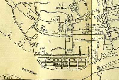
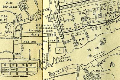
Part of a pre revolution map of Canton drawn by the Rev Daniel Vrooman of the American Board of Commissioners for Foreign Missions (ABCFM) in 1860. Our tour takes us to Fatei (Fati) at lower left, onto Shameen Island in lower centre, the Steamer landing on the Pearl River at right, and then to the Temple of the 500 Genii in upper centre. These areas were outside the old City walls, being shown by the dark lines drawn in the upper right hand corner. |
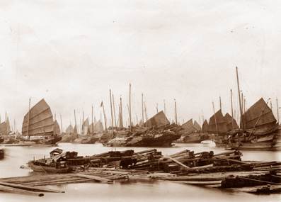
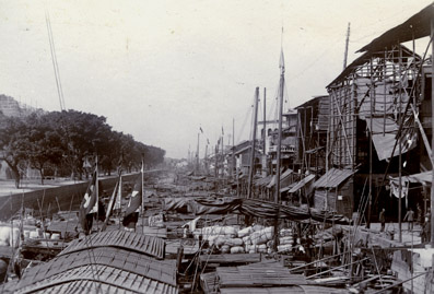
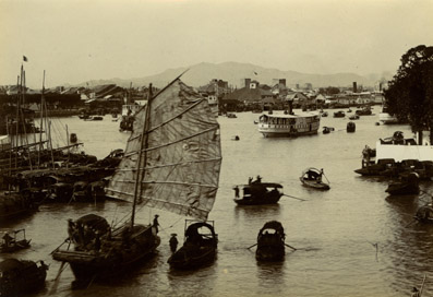
"A Bit of Shipping off Fati" Taken in 1903, this image shows junks in the crowded Pearl River opposite Fatie [Fati], being on the opposite south west side of the river from Canton and close to Shameen Island. Note the timber raft in foreground. |
|
|
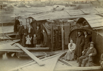
"Missionaries on the Way to Rebuild the Waste Places at Lien Chow"" America Presbyterian Missionaries on two houseboats at Fatei (Fati), Canton, prior to leaving for Lien Chow to re-open a Mission Station destroyed 28 Oct 1905. The party to Lien Chow consisted of Rev AJ Fischer, Rev & Mrs Rees F. Edwards, Miss Elda Patterson (seated at front), Dr & Mrs Ross, Rev JS Kinkle & Dr EC Machle. The children of Rev & Mrs Edwards are pictured in the second boat. Houseboats provided a relatively comfortable mode of travel. Many Missionaries, unaccustomed to the rigours of negotiating roughly formed country tracks on foot, resorted to travel by "chair" on long trips inland, being carried in a wicker chair suspended on poles by Chinese coolies.
|
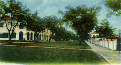
"Foreign Concession, Shameen Island" Most Europeans lived on Shameen Island bordering Canton City, ownership of land elsewhere by foreigners having previously been prohibited. The wide streets, well tended gardens and substantial dwellings were in stark contrast to the sights and sounds of old Canton. |
|
|
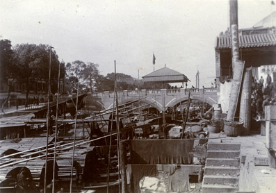
"Shameen Bridge" This attractive bridge across a canal connected Shameen Island with Canton City. The tent structure atop the bridge would presumably have provided shelter for officials controlling access to Shameen. Note the crowded wharf and the canal absolutely crammed with sampans. |
"Canal at Shameen " A view taken from Shameen Bridge looking down the crowded canal and street. The well-tended river bank on Shameen Island at left is in stark contrast to that of Canton City on the right. |
|
|
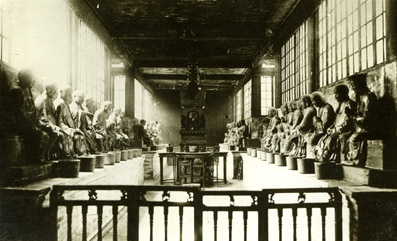
"Temple of the The 500 Genii" A glimpse inside this large Buddhist Temple due north of Shameen which was but one of numerous temples throughout the city. Such named temples in Canton included the Temple of Longevity, Temple of the 5 Genii, Temple of Horrors, Temple of Buddha, Temple of the Emperers, Confucian Temple, Taoist Temple, and the Temple of the God of War. |
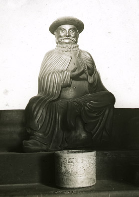
"Marco Polo" A close-up of the 'representation' of Marco Polo, the great 13th century Venetian traveller, in the temple of the 500 Genii. Famed as the first European to travel from Europe and then throughout China, his travels and exploits have become legendary. It appears that such was his enduring reputation in China that this image was named for him so that one could make an offering and prayer to his spirit. It appears however, that this representation was a later convenient Chinese 'invention', the temple actually containing 500 figures of Arhans or Buddhist saints! |
|
|
Eastwards from Shameen Island and past the Steamer Landing lies an area bordering the Pearl River which was later built up to form a wide concourse known as "The Bund". Honam lies on the opposite south bank of the river with the Roman Catholic Cathedral (marked "RCC") just inside the City wall at upper right. |
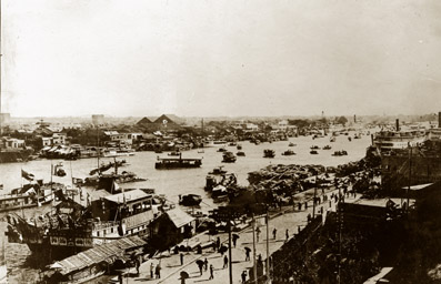
"Pearl River From Canton" This image appears to have been taken from Canton looking across the Pearl River to Honam Island. Shameen Island is just past the steamer wharf at far right. A rather large and elaborate junk is moored at left. The Bund, a large strip of land bordering the Pearl River, appears in the foreground. |
|
|
"Pearl River from Honam" A view taken from Honam Island looking across the busy Pearl River towards Canton City with the outline of White Cloud Mountain, 17 kilometers distant from Canton, at rear. Canton had a 'floating' population of at least 100,000 souls. On its waterways could be found sampans, 'great' boats, slipper boats, cargo boats, coffin boats, passage boats, ferry boats, theatrical boats, flower boats, house boats, leper boats, police boats, guard boats, customs boats, fishing boats, gunboats, steamboats, floating restaurants and brothels, and steam launches. |
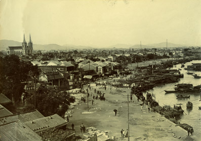
"Canton Looking North East" A view taken from near the steamer landing, looking north east along the Bund and over Canton city. The twin spired Catholic Cathedral stands out markedly on the city skyline. |
|
|
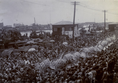
"Dragon Procession on the Bund" A large standing room only crowd watching a ceremonial 'dragon' procession making its way along the Bund, c.1911. |
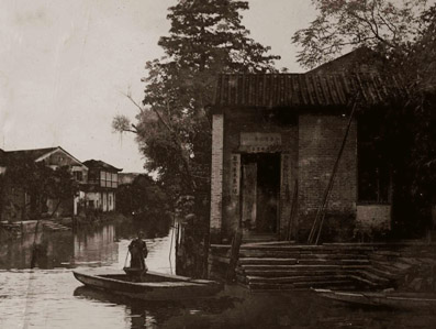
"Canal & Ferryboat" A canal ferry man in the western suburbs with his punt moored beside a landing stage, stone steps leading down to the water's edge. The long poles propped up against the building at right may very well be his poles for moving the punt through the water. Taken July 1906. |
|
Page One Page Two Page Three